


2013-05-18 Marche Ruines de Salm

holtzv
User GUIDE
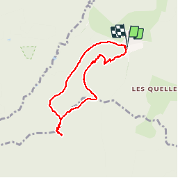

Length
6.9 km

Max alt
900 m

Uphill gradient
278 m
Km-Effort
10.6 km

Min alt
635 m

Downhill gradient
281 m
Boucle
Yes
Creation date :
2014-12-10 00:00:00.0
Updated on :
2014-12-10 00:00:00.0
2h38
Difficulty : Very easy

FREE GPS app for hiking
 SityTrail
IGN / Geographical institutes
SityTrail Plus
The world is yours!
About
Trail Walking of 6.9 km to be discovered at Grand Est, Bas-Rhin, La Broque. This trail is proposed by holtzv.
Positioning
Country:
France
Region :
Grand Est
Department/Province :
Bas-Rhin
Municipality :
La Broque
Location:
Unknown
Start:(Dec)
Start:(UTM)
363086 ; 5368558 (32U) N.
Comments
Bonjour,je pense que la rando n'est pas si facile si la descente s'effectue du côté de la Tête Pelée (roches glissantes).